MCT Joint R&D Achievement Wins First Prize in the 2026 Satellite Navigation and Positioning Science and Technology Awards
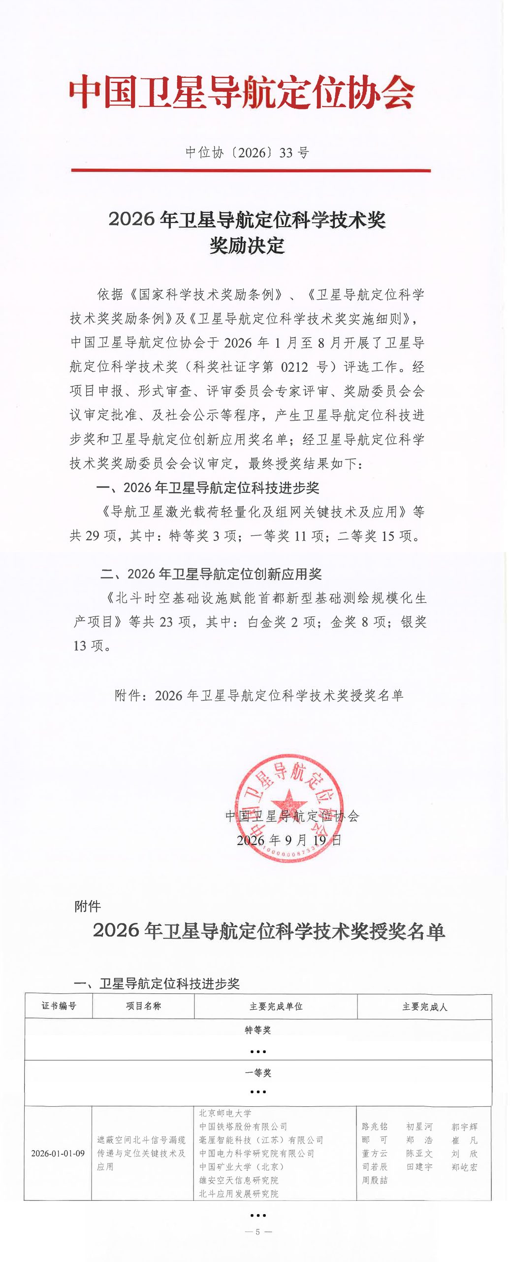
The project “Key Technologies and Applications for BeiDou Signal Transmission via Leaky Coaxial Cable and Positioning in GNSS-Denied Environments” has won First Prize in the Science and Technology Progress category of the 2026 Satellite Navigation and Positioning Science and Technology Award.
MCT Milli-Centi Intelligence, ranked third among the project’s principal contributing organizations, jointly completed the project with lead institution Beijing University of Posts and Telecommunications and partner organizations including China Tower, China Electric Power Research Institute, China University of Mining and Technology (Beijing), Xiong’an Institute of Aerospace Information, and Beidou Application Development Research Institute. Eleven projects received First Prize in this year’s Science and Technology Progress category.
Bringing BeiDou into GNSS-Denied Environments
In tunnels, mines, and large underground spaces, satellite signals are often blocked, making continuous positioning difficult. Bringing BeiDou signals into these environments and maintaining reliable positioning over long distances requires solving several challenges at once: signal coverage, alignment between indoor and outdoor spatiotemporal references, and positioning continuity.
The project team used leaky coaxial cable to carry BeiDou signals into these spaces. Cross-frequency differencing and virtual anchors helped establish a unified spatiotemporal reference, while satellite navigation was combined with inertial navigation to deliver continuous positioning.
The results have been demonstrated across more than 2 million square meters of underground space in the Rongdong area of Xiong’an New Area. They have also been tested in pilot applications involving tunnels, mines, rail transit, and other scenarios across China. By connecting signal transmission, reference alignment, and continuous positioning, the project has taken an integrated technical approach into real-world engineering environments.
From Core Chips to System-Level Validation
MCT Milli-Centi Intelligence was responsible for developing core chips, integrated positioning modules, and terminals for the project. To address the signal conditions in GNSS-denied environments, the company optimized multi-frequency signal reception and baseband processing on its self-developed MOJANDA 321 dual-frequency automotive-grade GNSS SoC. It also developed a tightly coupled continuous navigation algorithm combining an extended pseudorange model with a high-performance IMU, supporting the coordinated development of modules and terminals.
The project called for chips, algorithms, and terminals to work together in complex environments. Through its R&D and engineering validation, MCT Milli-Centi Intelligence demonstrated its capabilities in both core component development and integrated positioning systems. Related chips, modules, and terminals have also been validated in applications at selected mine tunnels and underground transit hubs. For industries that need continuous positioning in challenging environments, this work shows how the company can carry high-precision positioning from core technology into integrated systems and real-world settings.
From GNSS-Denied Environments to Intelligent Vehicles and Embodied AI
Continuous positioning in GNSS-denied environments addresses challenges beyond mines and tunnels.
For intelligent vehicles, tunnels, underground parking garages, and areas beneath elevated roads are common positioning gaps in urban assisted driving. The technology chain validated in this project—BeiDou signal transmission combined with continuous multi-sensor-fusion positioning—shares a common technical foundation with the company’s mass-produced automotive-grade integrated navigation products. MCT’s MOJANDA automotive-grade SoCs and tightly coupled navigation algorithms combining GNSS with high-performance IMUs have been deployed in more than one million intelligent vehicles, which have collectively traveled over 5 billion kilometers.
For embodied AI, a seamless indoor-outdoor spatiotemporal reference is also essential to large-scale robotic operations. MCT Milli-Centi Intelligence helped initiate the Embodied Intelligent Robotics Committee of the China Association of Satellite Navigation and Positioning and serves as its chairing organization. The company is extending its high-precision positioning capabilities to support robot positioning and spatiotemporal data capture, helping intelligent agents know where they are wherever they operate.
A Recognition Shared by Everyone in the Joint Effort
We are deeply proud of this First Prize. It reflects years of work by the project team and the close collaboration of all participating organizations in theoretical research, infrastructure, core equipment, and industry applications. MCT Milli-Centi Intelligence extends its sincere congratulations and thanks to Beijing University of Posts and Telecommunications, China Tower, China Electric Power Research Institute, China University of Mining and Technology (Beijing), Xiong’an Institute of Aerospace Information, Beidou Application Development Research Institute, and every member of the project team.
MCT Milli-Centi Intelligence will continue to advance BeiDou high-precision positioning, multi-sensor-fusion navigation, and spatial intelligence technologies. The company will keep refining its chips, algorithms, modules, and terminals through work in increasingly challenging environments. The results and recognition earned through this joint effort will inspire the company’s continued progress.